 The journey from stream to ocean begins in our backyards and farms.
Precipitation comes down, literally, everywhere—in many forms. It may rain,
hail, snow or sleet. Once it reaches the ground some water is absorbed by trees
and other plants.
Water not absorbed by roots enters the ground water supply. Most water runs off
the surface, down a hill and eventually into a river.
The Water “Network”
If you’ve
ever studied a map in detail, you will notice how rivers and streams form a
network of waterways across Pennsylvania.
- Streams
come together to form small rivers.
- Small
rivers join together and become medium-sized rivers.
- All
these rivers may be tributaries of a large river.
Collectively, the network of rivers and streams form a watershed
which drains the land of excess water.
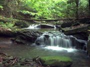
Rivers
- Think
about rivers as excess water disposal machines.
- Rivers
transport water from wherever it is to the
ocean.
- In
places where it rains more there are more rivers
and streams to deal with the large and consistent
annual rainfall.
Brief
History of Pennsylvania Rivers
Long before there were
highways and railroad tracks, the earliest residents of Pennsylvania moved from
one area of the state to another by using the Commonwealth’s natural
“roads” – more than 83,000 miles of
|
On
a rainy day look out the window and see if you can determine where
the water goes during a rain shower.
Does it flow down the street?
Does it flow down your backyard?
Are there man-made devices to capture or navigate
rain water?
What natural features are present that move water
into the banks of streams and rivers?
|
rivers, creeks and streams.
Through the years,
Pennsylvania’s waterways provided not only a way to move people, but a way to
move products where they needed to go. In
the early 1800s, a system of 1,200 miles of canals was set up to float people
and products to their destinations. The use of canals declined in the mid
1800s as railroads roared into Pennsylvania, taking both the passengers and
freight that needed to be moved.
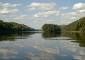
Today,
the rivers and streams of Pennsylvania provide opportunities for:

- Camping.
- Fishing
- Hiking.
- Canoeing and boating.
- A home, water and/or food for most species
of wildlife.
Special care is being taken
to prevent pollution or alleviate it if it already has occurred.
Rivers
in Pennsylvania are classified by the Pennsylvania
Scenic Rivers Act as:
- Wild
(free-flowing and supportive of native fish and aquatic life).
- Scenic (free-flowing and
capable of, or under restoration, to support water-based recreation, fish
and aquatic life).
- Pastoral (free-flowing
excepting historic or restored mill dams and capable of supporting
water-based recreation, fish and aquatic life, and the view from the river
or its banks shall be predominantly farming countryside).
- Recreational or modified recreational
(may combine free-flowing and relatively short stretches of impounded water
that can, or is being restored to, sustain appropriate water-based
recreation, fish and aquatic life and must be readily accessible).
Rivers may have more than
one designation.
For information about the
conditions of the streams and rivers in Pennsylvania, the threats to the
Commonwealth’s stream and river habitats, examples of wildlife that live in or
along the waterways, or actions being taken to preserve the waterways, contact
the Pennsylvania
Game Commission.
Contact the Pennsylvania
Fish and Boat Commission for a map of
Pennsylvania’s water trails (boat routes suitable for canoes, kayaks and
small motorized watercraft) or information regarding launch permits and paddling
safety tips.
Pennsylvania
Rivers
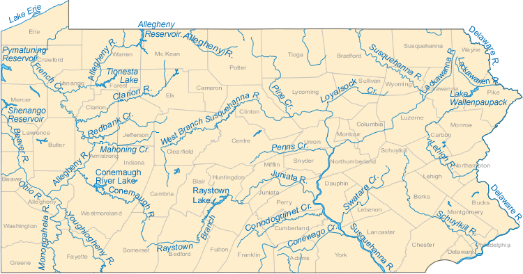
Allegheny
River, which rises in north central Pennsylvania about 10 miles
south of the border with New York, is approximately 325 miles long. From its
beginning point, it flows west, then takes a turn north into New York before it
re-enters Pennsylvania. It flows in a zigzag pattern across Pennsylvania,
forming part of the northern boundary of the Allegheny National Forest. The
Allegheney River, sometimes spelled Allegany
River, enters Pittsburgh in the city’s northern surburbs, then joins
the Monongahela River downtown to form the Ohio River.
Beaver
River,
which rises in Lawrence County in western Pennsylvania, flows generally south
for approximately 21 miles, roughly paralleling the Pennsylvania-Ohio border..
Casselman
River rises in western Pennsylvania and arcs up across Somerset
County, Pennsylvania, to the community of Confluence, where Laurel Hill Creek
joins it just above the Youghiogheny River.
Cheat
River
is formed in West Virginia, where a hydro-electric dam just across the border
from Pennsylvania causes it to widen into an area known as Cheat Lake Reservoir.
It then crosses a short distance through Fayette County, Pennsylvania, before
joining the Monongahela River. The Cheat is one of the largest undammed
watersheds in the eastern United States.
Chemung
River rises in New York, but flows east-southeast across northern Pennsylvania
until it joins the Susquehanna just south of Sayre. Its length is approximately
45 miles.
Christina
River, while only 35
miles long, extends into three states – Pennsylvania, Maryland and Delaware.
It rises in southeastern Pennsylvania in Chester County, then flows south across
a corner of Maryland, and finally east, past downtown Wilmington, Delaware,
where it forms the city’s harbor for traffic on the Delaware River.
Clarion
River forms in Elk County where the East Clarion River and the West Clarion River
meet, then flows generally west-southwest across western Pennsylvania where it
joins the Allegheney River in Clarion County. It is approximately 110 miles
long.
Conestoga
River rises from headwaters in southern Berks County, then flows southwest
through Lancaster County for approximately 50 miles to the Susquehanna River
approximately 16 miles north of the Pennsylvania-Maryland state line.
Delaware
River, approximately 410 miles long from the head of its
longest branch to its end, serves as part of the boundary between Pennsylvania and
New York, the entire boundary between Pennsylvania and New Jersey, and the
entire boundary between Delaware and New Jersey.
Genesee
River
rises south of Genesee, Pennsylvania. It is somewhat unusual in that its
waters flow north into New York until it empties into Lake Ontario. It features
falls at Letchworth State Park (the Grand Canyon of the East) near Portageville,
New York. The river was dammed in 1952 at Mount Morris, providing the largest
flood control dam east of the Mississippi River.
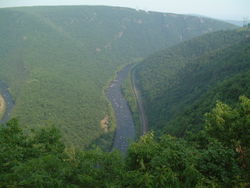
Juniata
River, an especially scenic river as it has a broad,
shallow course that passes through mountain ridges and gaps,
is approximately 90 miles long. It rises in Huntingdon County in central
Pennsylvania, then flows generally southeast to join the Susquehanna River about
15 miles northwest of Harrisburg.
Kiskiminetas
River (sometimes called the Kiski), forms in western Pennsylvania at
Saltsburg between Westmoreland and Indiana counties. Approximately 27 miles
long, it flows generally northwest until it joins the Allegheny River
approximately 25 miles northeast of Pittsburgh.
Lackawanna
River, approximately 35 miles long, flows through the Pocono Mountains in
northeastern Pennsylvania. The river rises in two branches, the west and east
branches, each of which is approximately 10 miles long. Closely parallelling
each other, both branches flow south and meet at the Stillwater Lake Reservoir,
then flow southwest to meet the Susquehanna River approximately 8 miles
west-southwest of Scranton, Pennsylvania.
Lackawaxen
River, approximately 25 miles long, rises in two branches in western
Pennsylvania in Wayne County, then flows through a largely rural area in the
northern Pocono Mountains. It flows south-southeast through Prompton Lake
Reservoir, past Honesdale, where it was deepened as part of the Delaware and
Hudson Canal project, then east to join the Delaware River at Lackawaxen.
Lehigh
River takes a winding 103-mile course from where it
rises in
the Pocono Mountains of northeastern Pennsylvania, first flowing southwest, then
south, then southeast, then northeast until it joins the Delaware River along
Pennsylvania’s border with New Jersey.
Little
Conemaugh River
rises along the western slop of the Appalachian Mountains in Cambria
County, then flows west-southwest through the mountains for approximately 30
miles until it is joined by the South Fork Little Conemaugh River and the
Stoneycreek River at Johnstown to form the Conemaugh River. One of the worst
disasters in U.S. history – known as the Johnstown Flood -- occurred on May
31, 1889, when more than 2,200 people drowned after the reservoir failed,
sending a wall of water up to 60 feet high down the Little Conemaugh at 40 miles
per hour.
Little
Juniata River,
sometimes called the "Little J,"
is formed at Altoona by the confluence of several short streams. It begins its
35-mile journey by flowing northeast between the Allegheny Ridge and Brush
Mountain, then it turns southeast past Huntingdon and joins the Raystown Branch
Juniata River three miles southeast of Huntingdon to form the Juniata River.
Mahoning
River, which rises in eastern Ohio,
crosses into Lawerence County, Pennsylvania on its 113-mile journey to join the
Shenango River near New Castle, Pennsylvania, to form the Beaver River. The
river features 15 dams along its pathway, which ranges from generally rural in
nature to heavily industrialized and heavily populated.
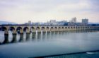
Monongahela
River, one of the largest rivers in the United States that flows generally
northward, is navigable its entire length with a series of locks and dams. Also
known as The Mon, the river is formed by
the confluence of the West Fork River and the Gygart Valley River in West
Virginia. It meets the Allegheny River at Pittsburgh to form the Ohio River.
Ohio
River flows through or along the border of six states –
Pennsylvania, Ohio, West Virginia, Kentucky, Indiana and Illinois -- on its
nearly 1,000-mile course. Formed by the confluence of the Allegheny River and
the Monongahela River at Pittsburgh, Pennsylvania, the river then flows
northwest through western Pennsylvania before turning south-southwest at the
triple border of West Virginia, Ohio and Pennsylvania just upstream from
Wheeling, West Virginia. It then heads west-southwest through several states
before joining the Mississippi River near Cairo, Illinois. The Ohio River has
the destinction of being designated as the southern boundary of the Northwest
Territory and as such, was the border between the free and slave states during
the Civil War era.
Schuylkill
River rises in two branches – the eastern branch in the
Appalachian Mountains in Schuylkill County and the western branch near
Minersville, Pennsylvania. They meet in Pottsville, Pennsylvania. The river,
approximately 130 miles long, passes through Reading, then joins the Delaware
River at the site of the former Philadelpha Navy Yard northeast of the
Philadelphia International Airport.
Shenango
River, which rises in Crawford County and flows into the Pymatuning Reservoir,
then turns south into Ohio before it returns to Pennsylvania where it flows into
Shenango River Lake, formed in 1965 when the U.S. Army Corps of Engineers
constructed a dam. It then flows southwest, joining the Mahoning River to form
Beaver River southwest of New Castle, Pennsylvania. It is approximately 100
miles long.
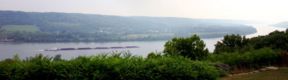
Susquehanna
River, formed from two main branches, one of which rises in New York and one of
which rises in Pennsylvania, is the longest river on the East Coast. At
approximately 410 miles long, it drains a large watershed within the Allegheny
Plateau of the Appalachian Mountains as it flows across the heartland of
Pennsylvania. It passes downtown Harrisburg (where it is nearly a mile wide and
can be seen from the state capitol), and flows southeast. It crosses into the
northern part of Maryland and finally enters the northern end of the Chesapeake
Bay in Harford County, Maryland.
Tioga
River,
approximately 55 miles long, rises in the mountains of western Bradford
County and flows southwest through Tioga State Forest before turning north
through Tioga Reservoir. It crosses into Steuben County, New York, near
Lawrenceville, Pennsylvania, joining the Cohocton River to form the Chemung
River.
Youghiogheny River winds
across parts of three states – West Virginia, Maryland and Pennsylvania –
for approximately 135 miles. It rises in Preston County in northern West
Virginia, then flows north-northeast into Garrett County, Maryland, roughly
parallelling the West Virginia border, separated by approximately 3 miles
It then enters southwestern Pennsylvania on the border between Fayette and
Somerset counties, flows northwest and joins the Monongahela River at
McKeesport. Approximately 6 miles north of the Pennsylvania border, the river is
held by an 184-foot high dam to form Youghiogheny River Lake, which stretches
into northern Maryland.